From The Neolithic To The Sea: A Journey From The Past To The Present
Via Gellia Lead Mines
Statistics
Category
County
Coordinates
Grid
Condition
Age
Admission
County
Coordinates
Grid
Condition
Age
Admission
Mined Valley
Derbyshire
53° 6' 32.8" N 1° 35' 25.1" W
-
-
1700
-
Derbyshire
53° 6' 32.8" N 1° 35' 25.1" W
-
-
1700
-
Map
- History
- Gallery
- Gallery
- Gallery
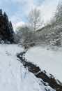
Via Gellia is a valley in the Derbyshire Peak District. It is a dry valley once formed by a river which now drains underground through caves. This valley has a karst topography, which is a landscape that has been shaped by the dissolution of layers of soluble bedrock such as limestone.
The valley is called Via Gellia after Phillip Eyre Gell. He had a road built through the valley in 1790, but as Gell claimed Roman descent the naming was latinised. The road connected all of Gell's lead mines to the smelter at Cromford. The valley has been mined from about 1700 commercially but may have been mined since before Roman times.
The limestone in Via Gellia is full of lead bearing veins due to a result of hydrothermal activity by volcanism. There are layers of basalt known as the 'lower Matlock lava bed' which is impermeable to water except where the valley cuts through and mine shafts dug to reach the lead veins.
There are many mines and adit's dug into the basalt and limestone, some on various levels. The Gulph Fault also runs through the valley which reveals more lead veins. The veins consist mostly of galena but include barytes, calcite and fluorspar.
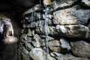
Gell's Lead Mine Adit is high in the wooded slopes of Via Gellia consisting mainly of a single mined passage with short interconnecting oxbows. It has four deep shafts cutting down following the lead ore, one of the shafts have side passageways cut.
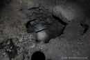
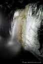
Bonsal Leys Level is a trial lead mine which was cut to try and find lead ore. It has a large entrance which can be seen from the road and a flooded passageway to about a foot deep. Waterfalls caused by faults in the rock flow down to the flooded floor.
The valley is called Via Gellia after Phillip Eyre Gell. He had a road built through the valley in 1790, but as Gell claimed Roman descent the naming was latinised. The road connected all of Gell's lead mines to the smelter at Cromford. The valley has been mined from about 1700 commercially but may have been mined since before Roman times.
The limestone in Via Gellia is full of lead bearing veins due to a result of hydrothermal activity by volcanism. There are layers of basalt known as the 'lower Matlock lava bed' which is impermeable to water except where the valley cuts through and mine shafts dug to reach the lead veins.
There are many mines and adit's dug into the basalt and limestone, some on various levels. The Gulph Fault also runs through the valley which reveals more lead veins. The veins consist mostly of galena but include barytes, calcite and fluorspar.
Gell's Lead Mine Adit is high in the wooded slopes of Via Gellia consisting mainly of a single mined passage with short interconnecting oxbows. It has four deep shafts cutting down following the lead ore, one of the shafts have side passageways cut.
Bonsal Leys Level is a trial lead mine which was cut to try and find lead ore. It has a large entrance which can be seen from the road and a flooded passageway to about a foot deep. Waterfalls caused by faults in the rock flow down to the flooded floor.